PURPOSE1 These Guidelines have been developed to promote the safe and effective use of shipborne
Automatic Identification Systems (AIS), in particular to inform the mariner about the operational
use, limits and potential uses of AIS. Consequently, AIS should be operated taking into account
these Guidelines.
2 Before using shipborne AIS, the user should fully understand the principle of the current
Guidelines and become familiar with the operation of the equipment, including the correct
interpretation of the displayed data. A description of the AIS system, particularly with respect to
shipborne AIS (including its components and connections), is contained in Annex 1.
Caution
Not al ships carry AIS
The officer of the watch (OOW) should always be aware that other ships, in particular
leisure craft, fishing boats and warships, and some coastal shore stations including Vessel
Traffic Service (VTS) centres, might not be fitted with AIS.
The OOW should always be aware that AIS fitted on other ships as a mandatory carriage
requirement might, under certain circumstances, be switched off on the master's
professional judgement. |
The internationally-adopted shipborne carriage requirements for AIS are contained in
SOLAS regulation V/19. The SOLAS Convention requires AIS to be fitted on certain ships
through a phased implementation period spanning from 1st July 2002 to 1st July 2008. In
addition, specific vessel types (e.g. warships, naval auxiliaries and ships owned/operated by
Governments) are not required to be fitted with AIS. Also, small vessels (e.g. leisure craft,
fishing boats) and certain other ships are exempt from carrying AIS. Moreover, ships fitted with
AIS might have the equipment switched off. Users are therefore cautioned always to bear in mind
that information provided by AIS may not be giving a complete or correct `picture’ of shipping
traffic in their vicinity. The guidance in this document on the inherent limitations of AIS and
their use in collision avoidance situations (see paragraphs 39 to 43) should therefore be heeded.
OBJECTIVES OF AIS4 AIS is intended to enhance: safety of life at sea; the safety and efficiency of navigation;
and the protection of the marine environment. SOLAS regulation V/19 requires that AIS
exchange data ship-to-ship and with shore-based facilities. Therefore, the purpose of AIS is to
help identify vessels; assist in target tracking; simplify information exchange (e.g. reduce verbal
mandatory ship reporting); and provide additional information to assist situation awareness. In
general, data received via AIS will improve the quality of the information available to the OOW,
whether at a shore surveillance station or on board a ship. AIS should become a useful source of supplementary information to that derived from navigational systems (including radar) and
therefore an important `tool’ in enhancing situation awareness of traffic confronting users.
DESCRIPTION OF AIS 5
5 Shipborne AIS (see Figure 1):
- continuously transmits ship's own data to other vessels and VTS stations;
- continuously receives data of other vessels and VTS stations; and
- displays this data.
6 When used with the appropriate graphical display, shipborne AIS enables provision of
fast, automatic information by calculating Closest Point of Approach (CPA) and Time to Closest
Point of Approach (TCPA) from the position information transmitted by the target vessels.
7 AIS operates primarily on two dedicated VHF channels. Where these channels are not
available regionally, the AIS is capable of being automatically switched to designated alternate
channels by means of a message from a shore facility. Where no shore based AIS or GMDSS
sea Area A1 station is in place, the AIS should be switched manually.
8 In practice, the capacity of the system is unlimited, allowing for a great number of ships
to be accommodated at the same time.
9 The AIS is able to detect ships within VHF/FM range around bends and behind islands, if
the landmasses are not too high. A typical value to be expected at sea is 20 to 30 nautical miles
depending on antenna height. With the help of repeater stations, the coverage for both ship and
VTS stations can be improved.
10 Information from a shipborne AIS is transmitted continuously and automatically without
any intervention or knowledge of the OOW. An AIS shore station might require updated ships within a defined sea area. However, the shore station can only increase the ships’ reporting
rate, not decrease it.
AIS INFORMATION SENT BY SHIPS
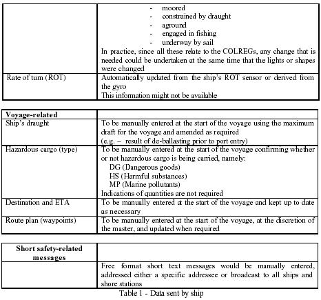
Ship’s data content11 The AIS information transmitted by a ship is of three different types:
- fixed or static information, which is entered into the AIS on installation and need
only be changed if the ship changes its name or undergoes a major conversion
from one ship type to another;
- dynamic information, which, apart from `Navigational status’ information, is
automatically updated from the ship sensors connected to AIS; and
- voyage-related information, which might need to be manually entered and updated
during the voyage.
12 Details of the information referred to above are given in table 1 below:

 13
13 The data is autonomously sent at different update rates:
- dynamic information dependent on speed and course alteration (see table 2),
- static and voyage-related data every 6 minutes or on request (AIS responds
automatically without user action).
 Short safety-related messages14
 Short safety-related messages are fixed or free format text messages addressed either to a
specified destination (MMSI) or all ships in the area. Their content should be relevant to the
safety of navigation, e.g. an iceberg sighted or a buoy not on station. Messages should be kept as
short as possible. The system allows up to 158 characters per message but the shorter the
message the more easily it will find free space for transmission. At present these messages are
not further regulated, to keep all possibilities open.
15 Operator acknowledgement may be requested by a text message.
16 Short safety-related messages are only an additional means of broadcasting maritime
safety information. Whilst their importance should not be underestimated, use of such messages
does not remove any of the requirements of the Global Maritime Distress and Safety System
(GMDSS).
17 The operator should ensure that he displays and considers incoming safety-related
messages and should send safety-related messages as required.
18 According to SOLAS regulation V/31 (Danger messages)
’The master of every ship which meets with dangerous ice, a dangerous derelict, or any
other direct danger to navigation, or ...is bound to communicate the information by all
the means at his disposal to ships at his vicinity, and also to the competent authorities...’. 19 Normally this is done via VHF voice communication, but ’by all the means’ now implies
the additional use of the AIS short messages application, which has the advantage of reducing
difficulties in understanding, especially when noting down the correct position.
Confidentiality20 When entering any data manually, consideration should be given to the confidentiality of
this information, especially when international agreements, rules or standards provide for the
protection of navigational information.
OPERATION OF AIS ON BOARDOPERATION OF THE TRAN SCEIVER UNIT Activation21 AIS should always be in operation when ships are underway or at anchor. If the master
believes that the continual operation of AIS might compromise the safety or security of his/her
ship, the AIS may be switched off. This might be the case in sea areas where pirates and armed
robbers are known to operate. Actions of this nature should always be recorded in the ship’s
logbook together with the reason for doing so. The master should however restart the AIS as
soon as the source of danger has disappeared. If the AIS is shut down, static data and voyage
related information remains stored. Restart is done by switching on the power to the AIS unit.
Ship’s own data will be transmitted after a two minute initialization period. In ports AIS
operation should be in accordance with port requirements.
Manual input of data
22 The OOW should manually input the following data at the start of the voyage and
whenever changes occur, using an input device such as a keyboard:
- ship’s draught;
- hazardous cargo;
- destination and ETA;
- route plan (way points);
- the correct navigational status; and
- short safety-related messages.
Check of information
23 To ensure that own ship’s static information is correct and up-to-date, the OOW should
check the data whenever there is a reason for it. As a minimum, this should be done once per
voyage or once per month, whichever is shorter. The data may be changed only on the authority
of the master.
24 The OOW should also periodically check the following dynamic information:
- positions given according to WGS 84;
- speed over ground; and
- sensor information.
25 After activation, an automatic built-in integrity test (BIIT) is performed. In the case of
any AIS malfunction an alarm is provided and the unit should stop transmitting.
26 The quality or accuracy of the ship sensor data input into AIS would not however be
checked by the BIIT circuitry before being broadcast to other ships and shore stations. The ship
should therefore carry out regular routine checks during a voyage to validate the accuracy of the
information being transmitted. The frequency of those checks would need to be increased in
coastal waters.
DISPLAY OF AIS DATA27 The AIS provides data that can be presented on the minimum display or on any suitable
display device as described in annex 1.
Minimum display28 The minimum mandated display provides not less than three lines of data consisting of
bearing, range and name of a selected ship. Other data of the ship can be displayed by horizontal
scrolling of data, but scrolling of bearing and range is not possible. Vertical scrolling will show
all the other ships known to the AIS.
Graphical display29 Where AIS information is used with a graphical display, the following target types are
recommended for display:
Sleeping target A sleeping target indicates only the presence of a vessel equipped with AIS
in a certain location. No additional information is presented until activated,
thus avoiding information overload.
Activated targetIf the user wants to know more about a vessel’s motion, he has simply
to activate the target (sleeping), so that the display shows immediately:
- a vector (speed and course over ground),
- the heading, and
- ROT indication (if available) to display actually initiated course
changes.
Selected target If the user wants detailed information on a target (activated or sleeping), he
may select it. Then the data received, as well as the calculated CPA and
TCPA values, will be shown in an alpha-numeric window.
The special navigation status will also be indicated in the alpha numeric
data field and not together with the target directly.
Dangerous target If an AIS target (activated or not) is calculated to pass pre-set CPA and
TCPA limits, it will be classified and displayed as a dangerous target and
an alarm will be given.
Lost target If a signal of any AIS target at a distance of less than a preset value is not
received, a lost target symbol will appear at the latest position and an alarm
will be given.
Symbols30 The user should be familiar with the symbology used in the graphical display provided.
INHERENT LIMITATIONS OF AIS31 The officer of the watch (OOW) should always be aware that other ships, in particular
leisure craft, fishing boats and warships, and some coastal shore stations including Vessel Traffic
Service (VTS) centres, might not be fitted with AIS.
32 The OOW should always be aware that other ships fitted with AIS as a mandatory
carriage requirement might switch off AIS under certain circumstances by professional
judgement of the master.
33 In other words, the information given by the AIS may not be a complete picture of the
situation around the ship.
34 The users must be aware that transmission of erroneous information implies a risk to
other ships as well as their own. The users remain responsible for all information entered into the
system and the information added by the sensors.
35 The accuracy of AIS information received is only as good as the accuracy of the AIS
information transmitted.
36 The OOW should be aware that poorly configured or calibrated ship sensors (position,
speed and heading sensors) might lead to incorrect information being transmitted. Incorrect
information about one ship displayed on the bridge of another could be dangerously confusing.
37 If no sensor is installed or if the sensor (e.g. the gyro) fails to provide data, the AIS
automatically transmits the "not available" data value. However, the built-in integrity check
cannot validate the contents of the data processed by the AIS.
38 It would not be prudent for the OOW to assume that the information received from other
ships is of a comparable quality and accuracy to that which might be available on own ship.
USE OF AIS IN COLLISION AVOIDANCE SITUATIONS39 The potential of AIS as an anti-collision device is recognized and AIS may be
recommended as such a device in due time.
40 Nevertheless, AIS information may be used to assist in collision avoidance decisionmaking.
When using the AIS in the ship-to-ship mode for anti-collision purposes, the following
cautionary points should be borne in mind:
.1 AIS is an additional source of navigational information. It does not replace, but
supports, navigational systems such as radar target-tracking and VTS; and
.2 the use of AIS does not negate the responsibility of the OOW to comply at all
times with the Collision Regulations.
41 The user should not rely on AIS as the sole information system, but should make use of
all safety-relevant information available.
42 The use of AIS on board ship is not intended to have any special impact on the
composition of the navigational watch, which should continue to be determined in accordance
with the STCW Convention.
43 Once a ship has been detected, AIS can assist in tracking it as a target. By monitoring the
information broadcast by that target, its actions can also be monitored. Changes in heading and
course are, for example, immediately apparent, and many of the problems common to tracking
targets by radar, namely clutter, target swap as ships pass close by and target loss following a fast
manoeuvre, do not affect AIS. AIS can also assist in the identification of targets, by name or call
sign and by ship type and navigational status.
ADDITIONAL AND POSSIBLE FUTURE APPLICATIONSAIS IN VTS OPERATIONS Pseudo AIS information44 VTS centres may send information about vessels which are not carrying AIS and which
are tracked only by VTS radar via the AIS to vessels equipped with AIS. Any pseudo AIS target
broadcast by VTS should be clearly identified as such. Particular care should always be taken
when using information which has been relayed by a third party. Accuracy of these targets may
not be as complete as actual directly-received targets, and the information content may not be as
extensive.
Text messages45 VTS centres may also send short messages either to one ship, all ships, or ships within a
certain range or in a special area, e.g.:
- (local) navigational warnings;
- traffic management information; and
- port management information.
46 A VTS operator may request, by a text message, an acknowledgement from the ship’s
operator.
Note: The VTS should continue to communicate via voice VHF. The importance of verbal
communication should not be underestimated. This is important to enable the VTS
operator to: - assess vessels’ communicative ability; and
- establish a direct communication link which would be needed in critical situations.
(D)GNSS corrections
47 (D)GNSS corrections may be sent by VTS centres via AIS.
MANDATORY SHIP REPOR TING SYSTEMS48 AIS is expected to play a major role in ship reporting systems. The information required
by coastal authorities in such systems is typically included in the static voyage-related and
dynamic data automatically provided by the AIS system. The use of the AIS long-range feature,
where information is exchanged via communications satellite, may be implemented to satisfy the
requirements of some ship reporting systems.
AIS IN SAR OPERATIONS 49 AIS may be used in search and rescue operations, especially in combined helicopter and
surface searches. AIS allows the direct presentation of the position of the vessel in distress on
other displays such as radar or ECS/ECDIS, which facilitates the task of SAR craft. For ships in
distress not equipped with AIS, the On Scene Co-ordinator (OSC) could create a pseudo AIS
target.
AIDS TO NAVIGATION 50 AIS, when fitted to selected fixed and floating aids to navigation can provide information
to the mariner such as:
- position;
- status;
- tidal and current data; and
- weather and visibility conditions.
AIS IN AN OVERALL INFORM ATION SYSTEM 51 AIS will play a role in an overall international maritime information system, supporting
voyage planning and monitoring. This will help Administrations to monitor all the vessels in
their areas of concern and to track dangerous cargo.
REFERENCE DOCUMENTS- IMO Recommendation on Performance Standards for a Universal Shipborne
Automatic Identification System (AIS), (MSC. 74(69), Annex 3)
- IMO SOLAS Convention Chapter V
- ITU Radio Regulations, Appendix S18, Table of Transmitting Frequencies in the
VHF Maritime Mobile Band
- ITU Recommendation on the Technical Characteristics for a Universal Shipborne
Automatic Identification System (AIS) Using Time Division Multiple Access in
the Maritime Mobile Band (ITU-R M.1371)
- IEC Standard 61993 Part 2: Universal Shipborne Automatic Identification System
(AIS) Operational and Performance Requirements, Methods of Testing and
required Test Results.